


This is an article from the fall 2018 issue of LSA Magazine. Read more stories from the magazine.
Geologist John Geissman (B.S. 1973, M.S. ’76, Ph.D. ’80) has a few tales about dodging life-ending experiences from his decades of working in the field. There was the time he almost got hit by lightning while doing field work near Butte, Montana. And another time, when he woke at three in the morning at a campground in Montana, after sleeping tentless on the ground and listening to the sounds of a grizzly bear attacking someone in a tent 20 feet away. More recently, he and an assistant got hit by a flash flood while deep inside a ravine in South Africa. Now, deep in South Africa’s Karoo Basin, Geissman and his colleagues are sampling ancient rocks, looking for clues that may reveal how Earth’s largest mass extinction unfolded.
Geissman is examining what’s called the Permian-Triassic (P–T) mass extinction. Also called the “Great Dying,” it happened about 252 million years ago and marks the boundary between the Permian and Triassic periods of geologic time. The story, as most geologists currently tell it, goes like this: Roughly 96 percent of all marine life and 70 percent of all land life disappeared forever.
From our perspective of “deep time,” the event looks sudden. But death did not arrive quickly. In the oceans, where the marine record is immaculately preserved, the P–T extinction spanned some 60,000 years. Most scientists think that the extinction is linked to major volcanic activity in what is today Siberia, where volcanoes disgorged roughly three million cubic kilometers of lava and emitted greenhouse gases such as carbon dioxide, which warmed the planet enough to help drive massive die-offs in the water. Studying extinction events like this shows that changes to our planet over the past century or so have been happening much more quickly than the global changes we’ve seen at other points in Earth’s history.
But Geissman and his colleagues are interested in what happened on land during that time. They’re trying to piece together how the extinction processes played out on dry turf, where vertebrates and plants also died off in great numbers — but differently.
This is the mystery. Could the “Great Dying” on land have been caused by something else altogether?
Secrets in the Stones
The P–T extinction is one of five major mass extinctions that punctuate history. Many paleontologists think that our human actions are currently driving a new and major mass extinction, with rates of species loss unseen since the extinction of the dinosaurs some 66 million years ago. If so, then the P–T event — also caused by planet-warming climate change — may be our best analogue for how this “sixth extinction” may unfold. Or, it may not turn out to be a good comparison at all, especially if some other extinction trigger is to blame.
At the center of this geologic mystery is a quarter-billion-year-old crime scene: the Karoo Basin. A broad, open, semi-desert expanse, the Karoo is one of the few places on Earth where rocks provide a record of the extinction on land. In the intervening 250 million years, most of the evidence has been lost to erosion and mountain building, and, unsurprisingly, not every geologist interprets the surviving clues in the same way.
For starters, it is not clear if what geologists have for decades described as the P–T extinction actually includes massive die-offs on land. There is some evidence, published by Geissman and his colleagues on the Karoo team, that the land crisis happened over one million years before the extinctions in the sea. If that is the case, then what caused the massive die-offs on land? At a field site near the small town of Bethulie, Free State, South Africa, this is what Geissman and his colleagues are hoping to find out.
Drilling Down
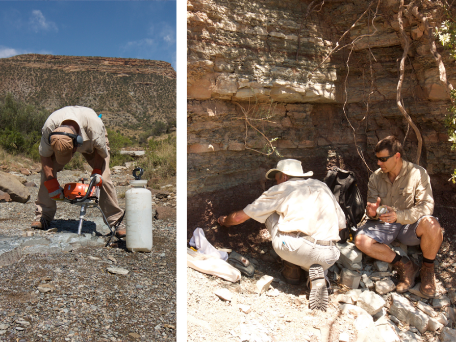
In South Africa’s January summertime, the grass is brown between the wild olive trees that dot the hills and sway in the wind. Nearby, baboons are barking. This is where Geissman and his team work.
Geissman doesn’t use a magnifying glass to find clues. Instead, he employs a portable drill powerful enough to bore through even the hardest rock. And rather than Sherlock Holmes’s deerstalker hat, Geissman wears industrial-grade earmuffs and a baseball cap with a big block “M” on it. He is ready to drill.
As a graduate student working with Professor Rob Van der Voo years ago in LSA’s Department of Earth and Environmental Sciences, Geissman learned to drill into rocks and measure their magnetic signatures. Out in the field today, Geissman hunches over a drill and handles it as if it’s another arm. In one rock face alone, he punches out 63 holes, each several inches deep.
From the cylindrical core samples he punches from rock, Geissman can measure the magnetic orientation of the rocks’ magnetic minerals. Every so often, the orientation of Earth’s magnetic field flips, and when it does, rocks formed after the “flip” form with a natural magnetism opposite to the prior direction of the magnetic field, and instead align with the new magnetic north. This means the rocks are like ancient compasses frozen in time — if you can see which way their “needle” is pointing, you can say where north was in the past. These geologically ancient magnetizations are quite weak, but readily measurable in the lab.
A global record of these magnetic flip-flops exists in Earth’s rocks, and Geissman wants to see if the record from the rocks in the Karoo fit the pattern of flip-flops known to characterize the boundary between the Permian and Triassic periods. If the flips in the Karoo match the global pattern, then the Siberian volcanism that caused the deaths at sea may have been responsible for the land deaths, as well. Researchers, then, could better connect the timing of the land extinction to the timing of the marine extinction.
If the magnetizations in the Karoo stray from the global pattern, though, then something strange is afoot, and the land extinctions may have arisen from something else entirely.
For now, the verdict is still out, and Geissman will continue to peer through his drill and persevere in the laboratory, seeking answers.

Field Guide
by Elizabeth Wason
John Geissman (B.S. 1973, M.S. ’76, Ph.D. ’80) first took the Geology & Mineralogy 440 course (Field Geology) as a student in 1973 at the Camp Davis Rocky Mountain Field Station, a teaching and research facility owned and operated by LSA. By the following summer, Geissman had negotiated himself into a TA position to help teach the class. Since then, he’s taught it for more than 40 years, missing just one year in all that time.
“I simply love the opportunity to interact with the students,” Geissman says about his repeated eager returns to camp. “I firmly believe that the best educational opportunity is one-on-one out in the field. It’s the best way to teach a subject like geoscience. Camp Davis is a precious educational and research facility.”
Over the decades, Geissman and Camp Davis have aged. Nearly 20 years ago, Geissman and his wife Molly (B.S.D.Hyg. 1974) — a professional artist who accompanies Geissman to camp as often as she can — recognized the need for a new classroom and office space at Camp Davis. Informally called the Dorr/Kelly Building, the name commemorates John A. Dorr, the Camp Davis director in 1965–1974, and Bill Kelly, professor emeritus in the Department of Earth and Environmental Sciences (EES) and a favorite mentor of Geissman’s.
Geissman is happy to support Camp Davis, where he hopes to join the kitchen staff when he retires from his day job. He says, “I’m pleased to see the loyalty of the geoscience alums, not only to EES, but also to Camp Davis.”