
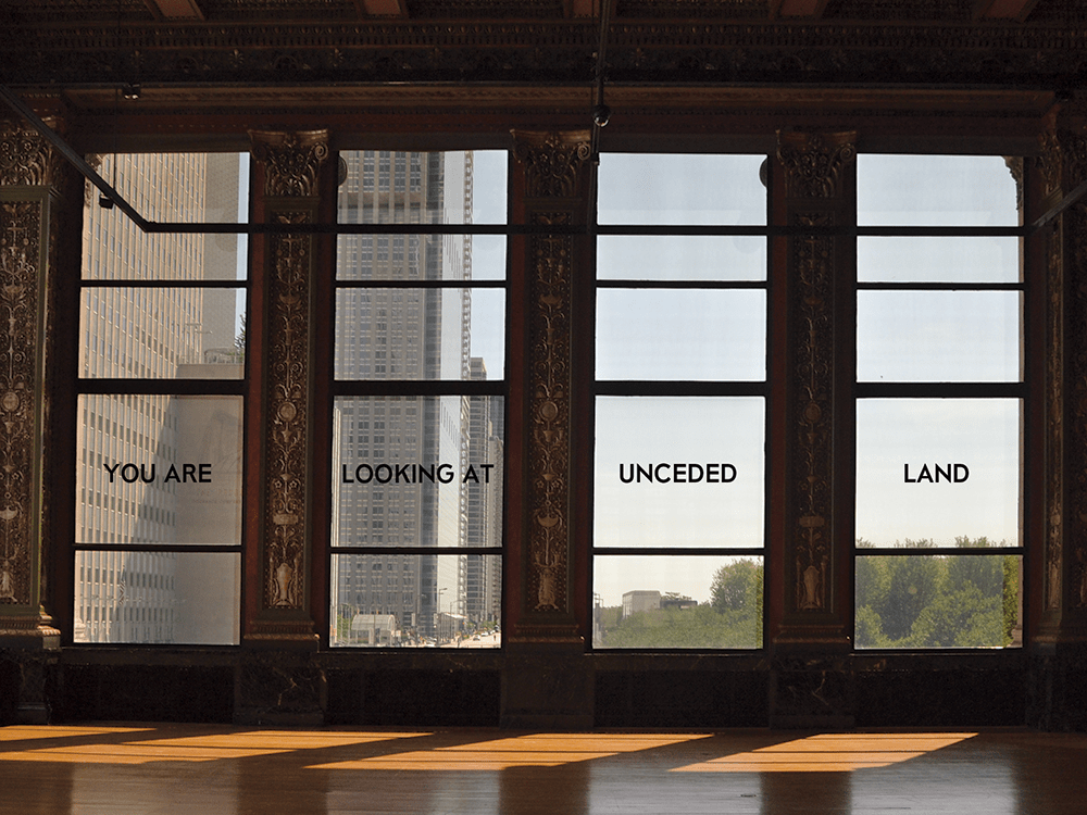
Rubble from the 1871 Fire was used to landfill the shoreline east of Michigan Avenue, creating new, unceded land. The Chicago Cultural Center stands at the threshold between ceded and unceded land.
This is an article from the spring 2020 issue of LSA Magazine. Read more stories from the magazine.
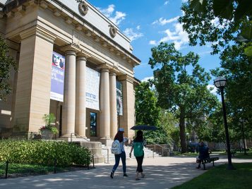
Looking out the east-facing windows of Yates Gallery at the Chicago Cultural Center, it’s easy to admire the wide territory the windows frame. A shoreline east of Michigan Avenue is still landfilled by rubble from the 1871 fire. Millennium Park, Grant Park, and Burnham Park have become urban landmarks on land that was once covered by the waters of Lake Michigan.
Taking a step back to better regard the view, you can more easily read the text painted across the windows in front of you: YOU ARE LOOKING AT UNCEDED LAND.
The words were part of an exhibit called the Settler Colonial City Project (SCCP) that ran from September 2019 to January 2020 as part of the Chicago Architecture Biennial. The exhibit was created by History of Art Assistant Professor Ana María León and Andrew Herscher, associate professor of architecture in the Taubman College of Architecture and Urban Planning and in history of art and Slavic languages and literatures.
When Herscher and León were first invited to present work at the 2019 Chicago Architecture Biennial, they used the opportunity to start a conversation about the settler-colonial history of the city.
Herscher endeavors to bring the study of architecture and cities across a range of global sites to bear on struggles for rights, justice, and democracy. León studies spatial histories. Her research and teaching centers on the modernity of the Americas as a landscape shaped by processes of colonialism, settler colonialism, and resistance. “We might think about settler colonialism as something that happened in the past,” León says, “but settler colonialism is ongoing, contemporary, all around us.”
Herscher and León wanted to center Native voices in the project. The pair reached out to Heather Miller, executive director of the American Indian Center (AIC) in Chicago, to listen, learn, and propose a collaboration. Over the course of the project, Herscher and León worked closely with Miller to put together public events on architecture, settler colonialism, and decolonization at both the AIC and the Chicago Cultural Center.
Through Miller, Herscher and León also began a conversation with John Low, a member of the Potawatomi Nation and a prolific scholar of the Potawatomi Nation’s relationship with Chicago. Low focused the attention of the SCCP on the continuing importance of Chicago’s Indigenous communities to the history of the city, and he also wrote the foreword to the exhibit’s “Mapping Chicagou/Chicago” publication.

The SCCP installation at the Chicago Cultural Center consisted of a series of signs that explain the entangled histories of the building and the people its construction displaced. The project mimicked the style of the Chicago Cultural Center’s official wayfinding and historical signage, working to complicate descriptions and dates with information about how these buildings came to be and hopefully working against what León describes as an “inability to grasp the settler colonialism all around us in our daily lives.” A massive wooden door sat behind a sign that read: “This mahogany was extracted from Indigenous land.” A panel at the building’s north entrance — in a room lavishly surfaced with marble — read: “This marble was quarried and assembled by exploited labor.”
Situated throughout the Cultural Center, the SCCP’s signs were intended to startle visitors and spark conversation. The project operated as an educational tool, as a political intervention, and also as architecture because it changed the perception and experience of the building.
Herscher describes the work of SCCP as “pedagogy for the public.”
“The project was meant to offer a more nuanced narrative of the building,” Herscher says. “In so doing, our intervention encouraged people to learn about the Chicago Cultural Center’s history.”
“The project really speaks to where architecture is today, which is struggling to reckon with its material, political, and social position in the world,” León says.

The Place of Wild Onions
“You are acquainted with this piece of land — the country we live in. Shall we give it up? Take notice, it is a small piece of land, and if we give it away, what will become of us?”
– Chief Metea at the 1821 Treaty of Chicago
About a hundred years after being driven off their land, Indigenous people returned to their native Chicago in large numbers as a result of the 1956 Indian Relocation Act. “After 400 years of killing Indians and trying to get them off the land, the federal government went to relocation, went to reservations. It gave Native folks a hundred bucks and a bus ticket and told them to go to the cities,” says Heather Miller. “Folks that arrived in cities needed community.” That’s where the American Indian Center of Chicago steps in.
Founded in 1953, the American Indian Center of Chicago is the oldest Indian center in the United States, and it serves the third-largest urban Indigenous population among U.S. cities. “People don’t know that we still exist. They think we’re dead — they don’t know that we thrive,” says Miller, who belongs to the Wyandotte Nation from Oklahoma. Since its founding, the AIC of Chicago has been a space where people can practice their heritage and celebrate their history.
The atlas that the Settler Colonial City Project (SCCP) included in its exhibit used the familiar techniques of colonial cartography to map the unfamiliar Indigenous history of Chicago or Chicagou, an Indigenous name for the place where the wild onions known as shikaakwa grew wild and abundant in the forests. The atlas documents how hills were flattened, the river was re-shaped, the shoreline was landfilled, buildings sprang up on Native land, and Native people were displaced. And yet, the atlas also reveals how present-day Chicago is a city with a thriving Native community: a city where powwows take place in a high school gym, a gallery space curated by Native artists is packed for an opening downtown, Native seniors meet for lunch at a community center, and Native youth tend the ramps in their community garden.
León and Herscher worked with a larger team of architects and architecture students, including recent Taubman alums Emily Kutil (M. Architecture ’13) and Tyler Schaafsma (M. Architecture ’18). Using the design skills they honed at U-M, Kutil and Schaafsma visualized the timelines and landmarks of Chicago and Chicagou, studied Potawatomi scholar John Low’s history of the city, and pulled together Library of Congress materials to map treaties and draw boundaries, making the data fit together like a puzzle.
Working with a minimal palette, Schaafsma marked political and architectural variations with hard gridded graphs to demonstrate how settlers had erased the organic forms of Indigenous communities and the natural, pre-settler state of the land. Schaafsma is committed to bringing the awareness he practiced in the mapping project to his future work.
“Once you start looking, you see the erasure and misportrayals everywhere,” Schaafsma says. “Once you learn the treaties and the history you become aware of this presence.”
- Learn About Supporting the Department of the History of Art and the Department of Slavic Languages and Literature