


When in Rome
This is an article from the fall 2019 issue of LSA Magazine. Read more stories from the magazine.
The mythological history of Rome says that twin brothers Romulus and Remus were put in a basket to be drowned only to have the river flood and bring them to a wolf, who raised the boys as her own. When they were grown, Romulus and Remus wanted to found a city they could rule. According to legend, that city was Rome.
Ancient mythologists were likely inspired by the Tiber River for Rome’s origin story, and rightly so. The river is prone to flooding, just like in the twins’ tale, and it has played an important part in Rome’s success as city, state, and global empire.
But what was it about Rome’s location along the 252-mile river that made it special, especially with so many other budding, competing cities nearby? What made Rome able to grow and thrive the way it did?
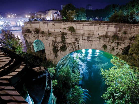
According to Laura Motta, who works as a lecturer in LSA’s Department of Classical Studies and researcher with the Kelsey Museum of Archaeology, part of the answer may be found in a sudden buildup of sediment that created the Tiber Island in the heart of Rome.
Motta’s research — a meld of archaeology, geology, and environmental science — shows that the island may have been created very suddenly by a shift in the river’s regime in the area of Rome in the sixth century BCE. This shift was created by a fault line that toppled the topography above it. As a result, the Tiber River changed course, and silt from the altered landscape built up in its waters at unprecedented rates. Within the short span of 100 years — a relatively short timeframe to a geologist — the island had formed.
And this was the game changer.
“The Tiber Island was crucial as a ford to cross the river,” says Motta. The island slowed the flow of the river and allowed Romans to build the first bridge across the water. The island fostered the growth of the city’s first river harbor. Goods could be shipped, sold, and traded here in a way they couldn’t anywhere else along the river.
“The traditional story says that Rome became Rome because it was founded in the perfect spot,” Motta says. “Instead it seems that the settlement existed there, and then all of a sudden the island appeared, and it became the perfect spot. So the real story is a little bit different.”
Drill, Baby, Drill
Motta’s evidence for the fault line was the result of a coordinated research effort between archaeologists, geologists, and volcanologists from two continents to drill and collect core samples of sediments in the heart of ancient Rome. The researchers pulled out sections from between 15 and 50 meters below the city to better understand the city’s environmental history.
Motta studied the samples, looking at “differences in the sediments in terms of color, texture, and inclusions.” This material, she explains, gives scientists evidence about “the movement of the river sediment and the pace at which it’s being deposited. We sift samples of these columns to look for organic material, and use that organic material to date the deposit.”
Motta says she observed many inconsistencies in the sediments that couldn’t be explained by climate alone, including a huge increase in sedimentation at one point. “It’s a very localized thing, and we think a fault line could explain it.”
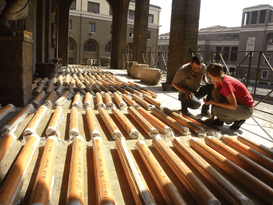
Core samples were key to the research team discovering what might have been rapid changes in the valley around the Tiber River approximately 2,600 years ago. Photo courtesy of Laura Motta
Motta’s working hypothesis is that the fault line caused one side of the valley to collapse, trapping sediment there and ultimately causing a buildup in the river that eventually became Tiber Island.
This work could provide missing details to explain the circumstances that allowed Rome to go from being one of many similar cities along the Tiber River to a regional superpower and, ultimately, a global empire.
Motta says that understanding how the physical landscape changed in this time period is critical to understanding the social, political, and economic development of early Rome.
“Our goal is to connect environmental processes and events to archaeological materials and specific human actions. Then, we can chronologically connect it to the historical context.”
Climate Change and Rome’s Bread Basket
Motta’s research also includes projects that test material a little closer to home, in samples preserved at the Kelsey Museum of Archaeology.
Noted academic and archaeologist Francis Kelsey excavated materials in Karanis, Egypt, from 1924 to 1935. The village was a treasure trove of artifacts that revealed insights about the daily lives of everyday Egyptians during Roman times, including the pottery they used, what kinds of crops they planted, the texts they wrote, and more.
Kelsey also excavated and preserved plant-based materials from houses and granaries in Karanis, which Motta is eager to study since the area in and around the village was producing crops that were being shipped to Rome. “Egypt was the bread basket of imperial Rome,” Motta says, “and Karanis was part of this commercial enterprise and system.”
Motta’s goal is to use DNA and isotopic analysis to gain insight into nutrition during this time. Motta and collaborators at the Free University of Brussels will analyze the nutritional values of Karanis’s ancient varieties of crops, looking at micronutrients such as zinc, iron, manganese, potassium, and proteins, and investigating how Egyptians were growing these grains.
The team has taken on this work with the hopes of testing and possibly disproving long-held assumptions about the quality of food for Egyptian nobles, farmers, and everyone in between.
“There is an assumption that nutrition in antiquity was very different between the upper and lower classes, that the upper classes had access to foods rich in nutritional value and the lower classes basically had a diet focused on staple cereals and some legumes. The problem is that most of the data used to assess nutritional values is gathered from modern foods and materials, which aren’t necessarily the same thing people were eating 2,000 years ago.”
Motta points out that high-yield grains were first developed during the 1950s and ’60s to increase agricultural output worldwide, and that those developments may have changed the nutritional value of the food.
“Modern varieties and the modern way of growing the crops affects the micronutrients a food contains,” she continues. “So this idea that lower classes in Egypt and Rome had poor nutritional value might be totally biased.”
This, she says, may provide insights valuable to modern-day humans as the climate changes due to global warming. Ancient grains may, Motta says, be more resilient in extreme environments. We’re just not sure yet. “There may be something that we can learn from these ancient crop varieties that can be applied to modern varieties,” Motta says.
To conduct this isotopic research and complete her core sampling work in Rome, Motta teams up with other researchers from around the globe and across the country. These projects are incredibly complicated, and require lots of different scholars to bring their specialized knowledge and wells of experience to cracking ancient problems and understanding the truly big picture of environmental, geological, and social-political evolution.
“You can’t do any of it alone,” Motta says. “You need the expertise and brainstorming and discussing things to add different points of view that are converging from different backgrounds. These are not my projects, they are our projects.”
- Learn About Supporting the Kelsey Museum of Archaeology
- Learn About Supporting the Department of Classical Studies